Fort Ballance
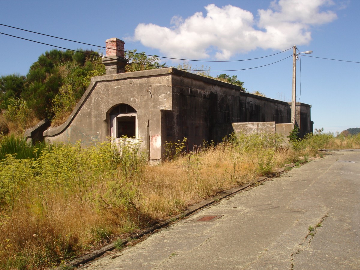

The barracks. Image: WCC, 2014
-
Fort Ballance Heritage Area is the name given to the area encompassing the historic coastal defence structures at Point Gordon on the eastern side of Miramar Peninsula. First established in 1885 as a hasty response to the ‘Russian Scare’ of the mid 1880s, the temporary defences were soon replaced by a permanent fort which survives to the present. Built on the site of an old Maori pa, Te Mahanga (the snare), Fort Ballance includes the distinctive Barracks building and an array of gun emplacements and fortifications. There are other battery elements within the area, including Fort Gordon (1893-96), Low Battery (1891) and Gordon Point Battery (1901). Other features within the area include searchlight emplacements, submarine mining facilities, a tramway, defensive ditches and the like, all of which have left significant marks on the landscape.
The area was intensely occupied through until 1911, when Fort Dorset, situated to command the harbour heads was built up to take over the role of the city’s most important coastal defence site; following this Fort Ballance’s strategic value was greatly diminished. However, Fort Ballance was reoccupied and reused for various defence purposes in World Wars I and II and was also in intermittent use between those wars.
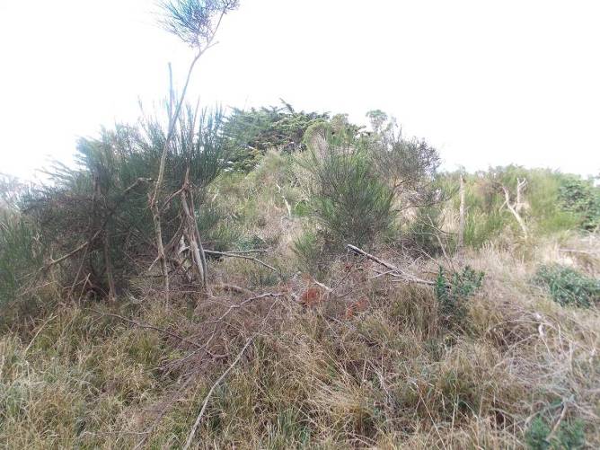
Time, tagging and vandalism, encroaching bush and vegetation, and the past efforts of the Army to demolish some of the structures, have taken their toll on the complex. The area is clothed in heavy bush in some places and many features have been covered over with earth. Nevertheless the greater part of the area’s structures are extant and in relatively good condition. Even structures ostensibly destroyed, like Fort Gordon, or covered over, like Gordon Point Battery, are thought to be largely intact beneath the surface. Complementing the area are the military roads, the first built in the 1880s from Shelly Bay to Fort Ballance, and Fort Ballance Road (1941) both of which are still mostly intact.
-
close
Physical Description
-
Setting
close
General
Fort Ballance occupies a hill-top site at Point Gordon on the Miramar Peninsula, with sweeping views out to sea past the South Wairarapa coast, around Wellington and to the Hutt Valley and beyond. From this elevated position, the Fort controlled the entrance to Wellington Harbour. The greater part of this end of the peninsula is reserve land and consequently the Fort sits at the heart of a substantial area of open space; this creates some visual continuity with its original open setting in bare and unpopulated farm land, an important part of the Fort’s historical character. The reserve land also has the effect of protecting long-standing views to and from the Fort from both land and sea. Two relatively small areas are reserved out of the site – a fisheries research station (the former submarine mining depot) at Kau Bay and an area for Telecom’s former satellite-earth station communications centre, the latter serviced by Fort Ballance Road.
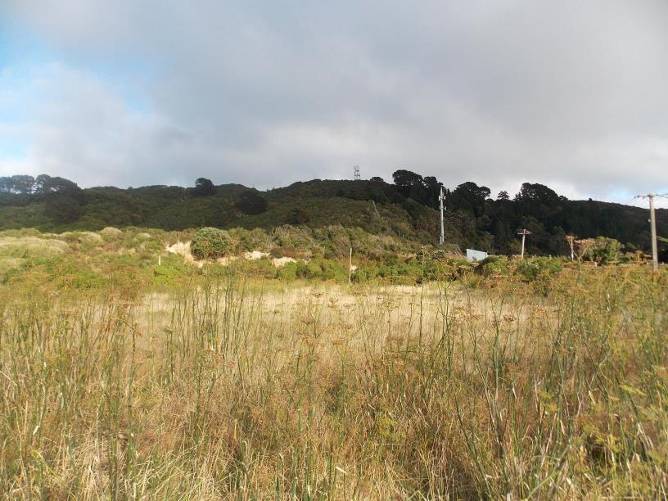
The broader setting of the Fort extends visually to either side of Mahanga Bay over the un-built hillsides that sweep around the peninsula from Kau Bay at the north to Scorching Bay at the south, curtailed at the western ridge-line to Mapuia. The land is rugged, a network of sharp ridges, spurs and gullies running out at coastal escarpments, and edged by the sea. The land is largely covered with dense bush, ranging from substantial stands of unmanaged mature pines to regenerating coastal scrub. It is cut, around the level of the fort, by the former military road that winds around to the north and ends up at Shelly Bay.
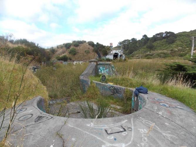
The immediate setting of the Fort comprises the flattened ridge-top at Point Gordon overlooking Mahanga and Scorching Bays, and the seaward hillsides and escarpments beyond that collectively contain all the surviving structures. The whole of the area is covered in vegetation – principally grass over the former camp area, but heavy growths of scrub and pines over the remainder of the site. As a result of the vegetation, although the site is relatively obvious from a distance due to the modified landscape, the major elements of the Fort are rather difficult to pick out from afar. The terrain and the vegetation mean that the smaller individual elements of the Fort are difficult to read together.
Fort Ballance
The Fort comprises an impressive collection of largely intact late 19th century military structures arranged around the site, including:
- Gun emplacements;
- Barracks building;
- Retaining walls, curtain walls, and ditches;
- Parade ground and former camp site;
- Minefield Control Station (and the remnants of the former submarine mining depot at Mahanga Bay)
- Fort Gordon
- “See-saw” searchlight
- The remains of the 12-pounder battery
- The remains of Low Battery
- The remains of the original tramway
- Fort Ballance Road
- The old military road to Shelly Bay
-
Streetscape or Landscape
close
Not available
-
Contents and Extent
close
Not available
-
Buildings
close
Fort Ballance
The Fort comprises an impressive collection of largely intact late 19th century military structures arranged around the site, including:
- Gun emplacements;
- Barracks building;
- Retaining walls, curtain walls, and ditches;
- Parade ground and former camp site;
- Minefield Control Station (and the remnants of the former submarine mining depot at Mahanga Bay)
- Fort Gordon
- “See-saw” searchlight
- The remains of the 12-pounder battery
- The remains of Low Battery
- The remains of the original tramway
- Fort Ballance Road
- The old military road to Shelly Bay
Construction
The complex has a mixture of above-ground and underground structures. All were built using a cut-and-cover method.
The fortifications are generally constructed of brick or concrete, and aside from the World War 2 era structures, are built with care and are uniformly and finely finished, a particular characteristic of Wellington’s Russian-scare fortifications. The exteriors are typically finished with a finely-detailed and crafted cement plaster, typically lined-out in imitation of stonework. Parapets have moulded copings to shed water, and the meeting lines of the various curved and straight features are carefully worked to be pleasing to the eye. Many of the structures have reinforced concrete components, some using railway irons as the reinforcement, or as permanent formwork.
The fort has been thoroughly stripped out over time and no ordnance remains on site, nor any metal equipment or fixtures of any note. However, the 8-inch RML barrel from the Fort Gordon battery was uncovered and retrieved in 2013, and it is possible there may be one or two gun barrels still buried somewhere on the land.
Fort and barracks
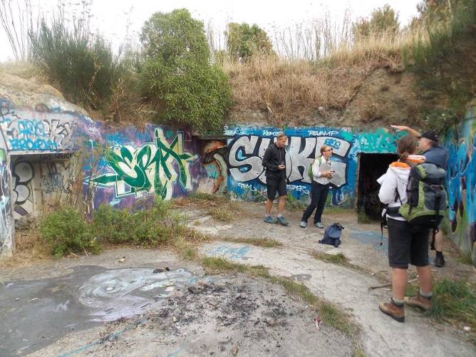
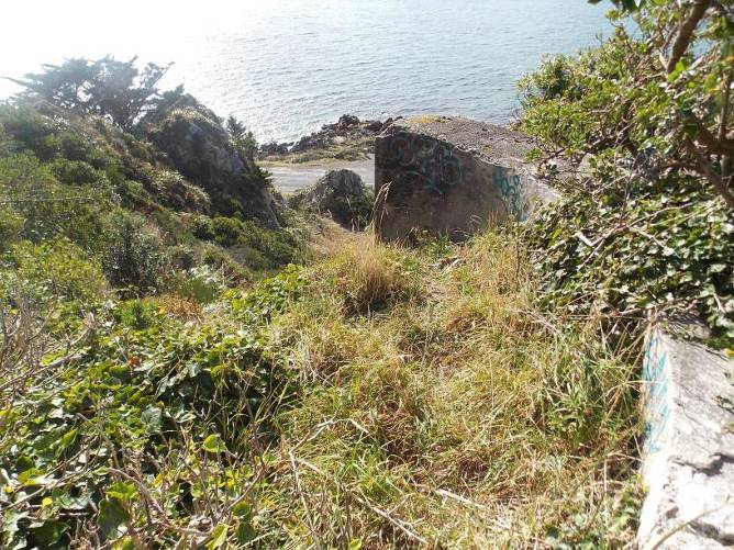
The fort proper is located at the eastern end of the flattened ridge, and the various battery structures associated directly with it run for some distance down the slope towards the sea to the north, east and south. A large flat area, covered in tall grass, with an asphalted driveway through the middle, is all that remains of the parade ground and army houses that previously stood on the site. The main section of the Fort includes the Barracks building and the open space behind it, the principal coastal defence gun emplacements and the quick-firing gun emplacements, two magazines, various observation posts and the associated fixed defences, all of which remain in-situ and relatively intact.
Set in the open, the most prominent physical feature of the Fort today is the Barracks building. This is a tall single-storey structure built into the back of a truncated section of ridge to provide shelter from bombardment, with an exposed main elevation facing west. Over the roof, a high cavalier includes three structures – the battery observation post, command post, and communications post. Of these, both the observation and communications posts are later structures built into the original walls. A plaster chimney, with a later brick extension, projects from the roof at either end of the building. The Barracks itself is a buried structure. It has a rectilinear plan, with a long main gallery (separate personnel and vehicle doors at either end), a fireplace at both ends, and a variety of rooms off the gallery to the east side, including an engine room, storage and service chambers.Fixed defences
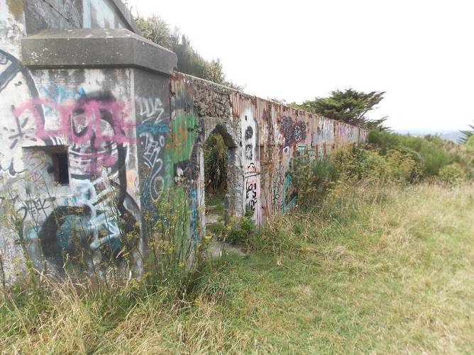
The original fort included a number of fixed defences against land-based assault on the seaward side, relying on the difficult terrain – and a well-armed garrison, to defend against any attack from the landward side.
The major features include the high retaining walls of the original gun emplacements and the broad ditch cut in front of them, which prevented direct access to the emplacements, and the trace walls either side of the main complex to guard the flanks. These consist of tall cantilevered concrete walls, filled between two layers of corrugated iron permanent formwork (the top edges of the corrugated were cut to spikes to deter climbing), reinforced with railway irons and other steel members and provided with closely-spaced loopholes. This defence was carried through to the rear wall of the Barracks
There is a rear trace formed by a wall of loop-holed casemate and continued by freestanding, corrugated iron-framed walls filled with rudimentary concrete, also with loopholes.
Gun emplacements and magazines
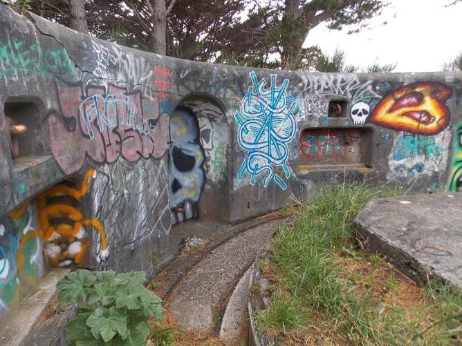
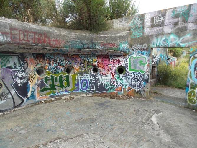
There are three surviving major gun emplacements, two for the 7-inch RMLs and one for the 6-inch disappearing gun, and two main magazines.
The northernmost RML emplacement is horseshoe-shape in plan with an open back. This emplacement features a cast-iron mounting plinth in the centre (probably not part of the original RML, but one of the few metal items left in the entire area), set on an octagonal concrete base elevated above the floor of the emplacement. There are two small vaulted chambers – magazines – set into the earth at the sides of the emplacement; the emplacement wall has a variety of formed niches, each with elegantly rounded heads, and three large ring-bolts set in near the top. A narrow-gauge rail, for an ammunition dolly, runs between the gun mount and the wall of the emplacement.
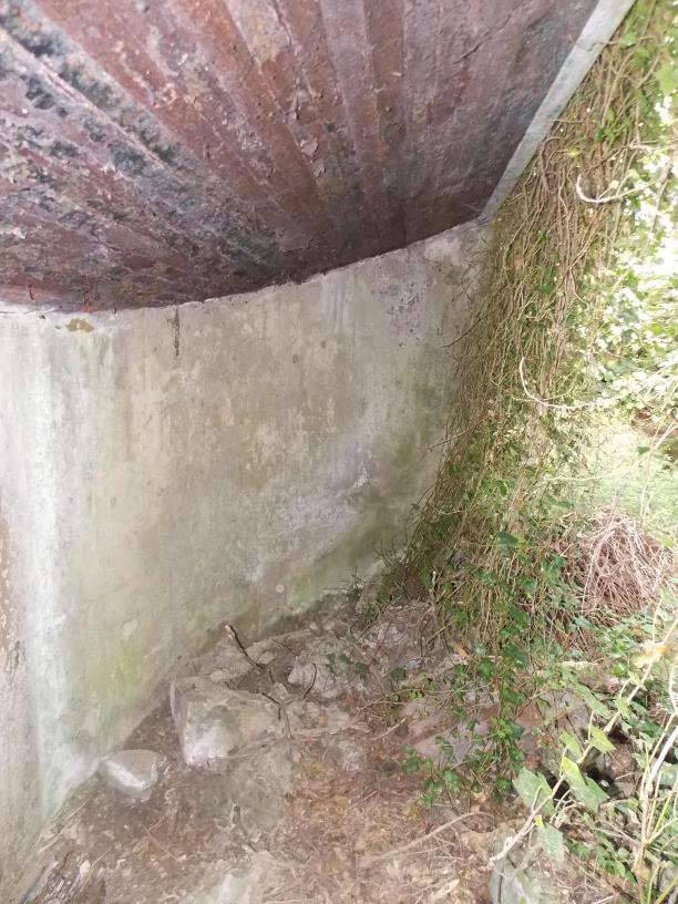
The northern magazine is built in plastered brick. It has an exposed exterior wall, facing west which features an external door and window openings, and a steel ladder rising up to an observation post above. The main passage takes an L-shape with a swept corner to arrive at the rear of the RML emplacement. A set of narrow-gauge rails runs down the centre of the passage, and there is a turntable near the emplacement end. The magazines are set off to either side of the passage, each flanked with a small lamp gallery. The interior shows the brick construction, and is subdivided into several magazine spaces, with attendant lamp galleries. There is a further level below ground, now entirely closed off.
The central emplacement, for the 6-inch disappearing gun, was accessed from the rear through a later concrete portal; the largest of the surviving emplacements, it is a deep semi-circular structure with a heavy moulded coping on the inside edge. It is perhaps most distinctive for the deep circular ram-rod recesses evenly spaced around the walls at the rear.
The southern magazine is accessed via a partly collapsed open passage off to the south side of the 6-inch gun emplacement. This magazine is built of both brick and concrete; the main passage ends up at the rear of the southern RML emplacement; there are a variety of magazine spaces off the passage, one with shallow brick vaults spanning between railway irons, others with flat ceilings
The southernmost RML emplacement, leading directly off the southern magazine, has a D-shaped plan similar to the first, but is configured differently, without the small magazine vaults to either side. The emplacement wall has the same arrangement of niches and ring bolts; but the top edge of the wall is roughly hacked off around the emplacement.
The two quick firing (QF) 6-pounder emplacements are the smallest of these emplacement structures. Flanking the main guns at either end of the fort, these were built as low semi-circular emplacements, protected with an earth embankment beyond a broad shallow concrete glacis, and accessed from the rear. The high retaining walls and ditch beyond served to protect these emplacements from close assault.
Minefield Control Station
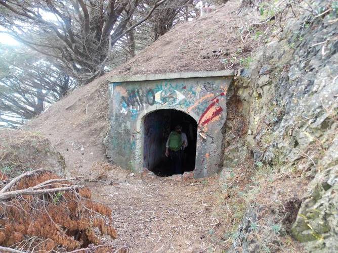
Situated to the north-east of the fort, some distance down the hill from the gun emplacements, this is the most extensive of the accessible underground structures. Access is gained via a small plastered portal cut into the shoulder of the hill. This had been bricked up at some point, but the opening has been broken out for many years. Beyond the portal, an equally small vestibule space lets on to a long tunnel of a segmental-arch profile that dog-legs and curves in plan, flanked with small magazine spaces to either side of the first section. The access tunnel eventually opens out to a larger brick-lined space with a high ceiling and containing an engine plinth, with the Control Station beyond. The Control Station itself is a compact observation post structure, buried in the ground; it has a semi-hexagonal front with a narrow observation slit facing out over the harbour passage. Remnant battens show where interior linings were once attached, and a large earthenware drainage pipe duct illustrates the route the signal cables took in the direction of Mahanga Bay.
Fort Gordon
Constructed down the ridge to the south-west from Fort Ballance, Fort Gordon had a single 8-inch disappearing gun, and although separately identified, was really just an extension of the main fortification. The gun emplacement, which was broadly similar to the other disappearing gun emplacements at the fort, although slightly larger in scale to suit the larger ordnance, was demolished by the Army after World War 2 with explosives and filled in. Despite this, the underground structures are thought to still be intact. There is no visible trace of a structure today, although the broken concrete from the demolition lies just under the ground cover. The gun barrel from this emplacement was located on the flank of the ridge and retrieved by the Army in 2013.
12-pdr battery (Gordon Point)
The remains of this battery are on top of the escarpment at the eastern extremity of the land, at about the mid-height between the foreshore and the main guns. They include two gun emplacements, separated by roughly 20m, a magazine, and a nearby war shelter. The structures are all presently buried, with only short sections of concrete wall visible to show their position. Part of the magazine can still be seen from the road below.
See-saw searchlight emplacement
This emplacement was entirely abandoned after the failed demolition attempt in 1899, and consequently, although nothing remains today of the searchlight mechanism, the emplacement remains substantially intact. It consists of a roughly circular pit scooped out of a sheltered depression in the side of the hill.
A tall semi-circular concrete wall with a smooth plaster finish makes up the east side; this has a heavy concrete overhang with a distinctive sloping soffit/permanent formwork made up of railway irons. The circular plan form is completed with a low plastered wall to the rear that meets into the base of the bank. The floor of the emplacement is partly covered with pieces of broken-up concrete and other debris.
Low Battery and searchlights
Very little remains of the Low Battery and the searchlights that were emplaced on the escarpment behind, just some isolated fragments of concrete plinths on the coastal rocks and side of the escarpment that are thought to date from the world war 2 era
-
Structures and Features
close
Construction
The complex has a mixture of above-ground and underground structures. All were built using a cut-and-cover method.
The fortifications are generally constructed of brick or concrete, and aside from the World War 2 era structures, are built with care and are uniformly and finely finished, a particular characteristic of Wellington’s Russian-scare fortifications. The exteriors are typically finished with a finely-detailed and crafted cement plaster, typically lined-out in imitation of stonework. Parapets have moulded copings to shed water, and the meeting lines of the various curved and straight features are carefully worked to be pleasing to the eye. Many of the structures have reinforced concrete components, some using railway irons as the reinforcement, or as permanent formwork.
The fort has been thoroughly stripped out over time and no ordnance remains on site, nor any metal equipment or fixtures of any note. However, the 8-inch RML barrel from the Fort Gordon battery was uncovered and retrieved in 2013, and it is possible there may be one or two gun barrels still buried somewhere on the land.
-
Other Features
close
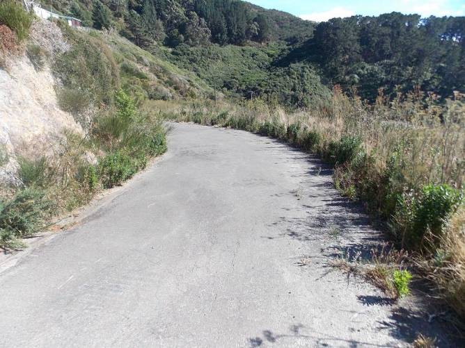
Roads and tramwaysFort Ballance Road is a relatively steep and winding single-lane road that rises from Mahanga Bay to the parade ground area. It is a modern formation, covered in asphalt, and is slowly degrading from a lack of maintenance.
The old military road, although technically not part of the heritage area, is an important adjunct to its history. It is a single lane benched road, gently rising as it wends its way around the spurs towards the north.
The alignment of the tramway up from Mahanga Bay can still be discerned, and there are fragments of rails and equipment to be found along its route. It is a largely archaeological feature.
-
Setting
close
-
close
Historic Context
-
1.1 History of area
Fort Ballance was constructed between 1885 and 1892 as a response to the second Russian Scare of 1885. The first scare, in 1878, had led the New Zealand government to the purchase of 22 RML [rifle muzzle loading] guns for coastal defence, but they were never emplaced. The anxiety arose from Czarist Russia fortifying the port of Vladivostok, on the Sea of Japan, in the 1870s and 1880s, and the Imperial Russian Navy consequently establishing a military presence in the North Pacific. This development caused a certain amount of irrational panic in both Australia and New Zealand in particular where, against all probability, a Russian invasion was feared. An ambitious programme of coastal defence battery construction was urgently undertaken to defend New Zealand’s major ports. However, the pace of construction later became more measured as the apparent threat receded.
Fort Ballance was named after the then Minister of Defence (and later Premier) John Ballance and built on the site of the abandoned Mahanga Pa, one of a string of notable pa that had been built by Maori over several centuries on the Miramar Peninsula. The peninsula, known as Motu Kairangi, was once an island before a massive earthquake in 1460 uplifted large areas of the Wellington region. A narrow isthmus was formed, joining the island to the land to the west. The area was further uplifted in the 1855 earthquake, establishing the large areas of flat land today occupied by Kilbirnie and Lyall Bay.
The land that the fort sits on was owned by John Coutts Crawford, who had settled on the peninsula in 1846. Work on the fort began in haste in 1885. The land was taken by the government and an emergency timber-built emplacement quickly erected by the Field Force of the New Zealand Constabulary Force. The emplacement contained two 7-inch RML guns separated by an open gallery. The muzzle-loading guns were obsolete by this time, but had the considerable advantage of being available at very short notice. In 1886, under the Public Works Act, the government acquired the whole of the tip of the Miramar Peninsula for defence purposes. Crawford was eventually paid compensation, but not before he took the matter through the courts in a bid to get what he regarded as suitable recompense.
The original design of Fort Ballance was by Major Cautley RE, who designed most of the country’s first forts. The permanent fortification was part of an expansive and costly exercise to erect permanent coastal defences at New Zealand’s major ports. Cautley’s work was continued by Lieutenant Colonel Tudor-Boddam, who oversaw the completion of the remaining structures. The construction of the fort on what was then a relatively remote hilltop site was a major exercise, and despite the initial urgency, it took over a decade for it to be completed.
Access to the site was difficult. Initially there was no road around or over the peninsula. A military road was eventually built over from Shelly Bay in the late 1880s and it survives, largely intact, to this day. A wharf had been built and a submarine mining base established on the foreshore at Mahanga Bay in 1885, and a tramway was built from there to the hilltop to move construction materials and assist in the ongoing supply of the fort.
Fort Ballance incorporated, along with the two 7-inch RMLs, one (modern) 6-inch breech loading, hydro-pneumatic (BLHP) Armstrong Vickers disappearing gun (work on the emplacement for this began in 1886), and two Nordenfelt quick-firing 6-pounder guns (1892), eventually emplaced on each flank of the fort. Some 160 metres of curtain wall and musketry loopholes were constructed, along with defensive ditches, accommodation and support facilities. There were two magazines, initially timber lined but later built of brick. To act as camouflage, earth excavated during construction was piled on top of the fort and covered in plantings. The camouflage may not have been especially effective in the first years of the fort’s use as early photos show the land all but bare of vegetation and the fort structures rather prominent in the landscape.
In 1891 the Low Battery (aptly named, it was built well below the fort) was constructed to cover the as yet un-laid minefield out in the harbour passage and the broad zone of dead water not able to be covered by the main guns behind. The battery armament consisted originally of 64-pounder guns, converted to RMLs and mounted on wooden carriages. These were replaced with new quick-firing guns on permanent mounts in 1897. The Low Battery was disarmed by 1908 when submarine mining ended. It was later used as a searchlight position in World War II but subsequently largely demolished, although portions of the battery still remain in situ.
The same year a ‘see-saw’ searchlight was emplaced to illuminate the minefield and sweep the harbour. Although innovative, it did not work well and it was quickly superseded by more effective new technology. Attempts to blow the emplacement up in 1899 resulted in the deaths of three engineers when charges detonated prematurely. Also in 1891, work began on Mt Crawford Redoubt, an infantry position constructed in earthworks and built by prisoners directly behind (to defend) Fort Ballance. It was the last redoubt built in New Zealand and part of it survives to this day, albeit now concealed under scrub.
Between 1893 and 1896, a further fortification (an 8-inch BHLP disappearing gun) was built on top of the ridge 80 metres south of the southern edge of Fort Ballance. Named Fort Gordon, it consisted of this gun and an attached Hotchkiss quick-firing [QF] 3-pounder, known as Spur Battery.
In 1895, a second 6-inch BLHP disappearing gun was emplaced in the southern RML pit. During the 1890s the 6-inch gun barrels were sent back to the United Kingdom for strengthening and in most cases they were not returned to their original locations. In 1904 a control post for the minefield laid across the harbour at Mahanga Bay was built in the lower north-east corner of the fort, completely separate from the main part of the fort.
By 1898 Wellington boasted seven defensive fortifications around the harbour – the four fortresses, Ballance, Buckley, Gordon and Kelburne, and further gun batteries at the Botanic Gardens, Point Halswell and Kau Point.
In 1901, a new 12-pounder battery (Gordon Point Battery) was built just to the south of and slightly above the Low Battery. These guns served as the Examination Battery during World War I, commanding the examination anchorage at Mahanga Bay. A gunner was killed, and five others injured, when the breech blew out of the 12-pounder during a firing exercise on 2 November 1904.
The fort’s primary defensive role in Wellington was taken over by Fort Dorset in 1910-11, and after this time Fort Ballance changed relatively little, having been relegated to a secondary role. However, the fort remained armed through World War I. The disappearing guns were scrapped in 1924 and the gunpits were roofed and converted into magazine storage. The 12-pounders were moved to Fort Dorset, where they were reused to cover a new examination anchorage at Breaker Bay. By the late 1920s only a caretaker lived on-site (in a purpose-built cottage erected in 1928).
The fort was reoccupied for coastal defence in 1941 when two 4-inch MkVII guns (ex-HMS New Zealand) were removed from Fort Dorset and mounted on the old 12pounder positions. The men stationed there initially had to occupy the old fort barracks which were ‘unpleasantly damp’. To properly house the battery personnel a camp was built in 1941 behind the fort on land that had been bulldozed flat for the purpose. The present road from Mahanga Bay, linking on to the coast road, was constructed to give access to the site and three timber barrack blocks, a cookhouse, mess and other buildings were constructed to accommodate the complement of up to 177 men stationed there. The new road cut across the line of the long abandoned tramway. In 1942 two 75mm guns, provided by the United States, were emplaced near the 4-inch guns. In 1944, a new 6-pounder position was set up near the shore and this took over from the other guns.
After the war Fort Ballance was kept in military service as an ammunition store. The guns were scrapped (the barrels were disposed on site, and the carriages and other moveable fittings broken down and taken away) and all the gunpits were filled in. The camp buildings were removed, and replaced by six houses, arranged around the end of Fort Ballance Road; these houses were removed decades later in the early 1990s, with the last house – that of the caretaker – being removed in 2004. There are now no outbuildings associated with the fort still standing.
The various fortifications outside the main fort were mostly demolished or filled in during 1969-1970, including the World War I and II structures, the Fort Gordon 8inch gun pit, a guard house at the bottom of the access road, and the buildings associated with the 12-pounder battery.
During its long period of service, Fort Ballance was garrisoned by a series of different military units. The Wellington Naval Artillery Volunteers was the first – until 1902. It was followed by the No. 4 Company New Zealand Garrison Artillery Volunteers, until 1907, an unknown Company to 1911, No. 5 Company to the end of War I and then the 15 Battery New Zealand Artillery from the end of World War I to 1939, (although the Fort was barely occupied in the inter-war period). When use of the Fort was revived in World War II, 10 Heavy Regiment RNZA took over.
Retired soldiers led efforts in the early 1990s to have the earth removed from the emplacements and other structures and the fort’s heritage significance given wider recognition. The Fort was given an A Classification by the New Zealand Historic Places Trust in 1990 (it is now registered Category I by Heritage New Zealand).
Beyond the excavation of the principal gun emplacements and occasional clearance of vegetation, little has happened on the site in the intervening years. Following the end of the military presence at the site – as with the majority of former military sites – taggers and vandals have made extensive use of the site’s hard surfaces and today most of the visible parts of the fort are covered in multiple layers of graffiti. In 2013, the barrel of a disappearing gun was located and excavated at Fort Gordon, to much publicity.
Fort Ballance is still in NZDF hands, pending transfer to DOC and its probable future role in a regional park. The structures are still largely intact, but vandalism, tagging and the effects of age are taking their toll.
1.2 History of key structures
Fort Ballance
Work on the fortification began in 1885 with the hasty temporary installation of the two 7-inch RMLs, using sandbags as protective walls. Construction of permanent defences (mainly brick, with plastered walls) began the following year and along with the RML emplacements, a further 6-inch disappearing gun emplacement was built between the RMLs. Two quick firing 6-pounder guns were also emplaced at this time but not in their present (flanking) positions until 1891. Two magazines were constructed, initially lined in timber but then re-built in brick to combat leaks and decay. Barracks accommodation was built at the rear of the fort, alongside a minefield test room and an engine room for the searchlight located near the bottom of the point. Loopholed defensive walls were built on each flank, along with protective ditches, to guard against land-borne attacks; the flank walls ingeniously utilising concrete poured between sheets of corrugated iron.
In the early 1890s, spoil from the formation of the front walls was carried to the top of the fort and laid on the roof. It was planted with vegetation (ice plants) both to act as a camouflage and to hold the earth in place. Ice plants are still a feature of the site today. Also at this time, the southern RML emplacement was converted into another 6-inch emplacement, and an observation post built on the barracks roof, complemented by a telephone room connecting Fort Ballance with other forts on the peninsula. Principal works on the fort were largely completed by 1895.
Parade ground / barracks accommodation (at rear)
In 1941, 30 men were stationed at Fort Ballance to man the Examination Battery. Initially they had to sleep in the damp and notably uncomfortable old barracks. A parade ground was levelled behind the fort and very quickly three new huts, each sleeping 40 men, were built. These buildings were removed after the war and six new houses were built in their place as accommodation for army personnel. The last of these houses, the caretaker’s residence, was finally removed in 2004, and today there is little above-ground evidence of their presence.
Minefield Control Station
Completely separated from the main fort but located under its north-east flank, the minefield control post and engine room was built in 1904 to monitor the minefield then planned to be laid across the entrance to Wellington harbour, out from Point Gordon to Makaro/Ward Island. Communications cables were laid from the main fort to the control post, and control cables from the control post to the minefield.
As Cooke describes it, the station would have operated as follows in a time of conflict:
An instrument installed at the time combined a telescope with a plotting board which determined exactly where the mines were. If the crosshairs of the telescope were kept on the vessel it could detonate individual mine loops automatically as the shop passed over them. The minefield was only laid in part in exercises but its position was reused for the field laid in anger in World War II.[1]
Fort Gordon
A short distance south of the Fort Ballance barracks building, Fort Gordon occupied the top of a slightly lower spur. This area was significantly altered to accommodate a new 8-inch disappearing-gun battery. The gun was hurriedly emplaced in 1892 and then the remainder of the work – underground magazines and concrete emplacement – was undertaken over the following three years using labour from the nearby Mount Crawford prison. Later in the 1890s, a 3-pounder Hotchkiss gun was emplaced adjacent to the 8-inch battery. The latter was named Spur Battery, and had a short working life as it was removed in World War I, following the completion of the 6-inch battery at Point Dorset in 1911.
In 1924, the 8-inch gun barrel was removed and thrown down the bank to the immediate north of the emplacement. The emplacement was converted into a magazine, roofed over for that purpose. After World War II, the roof was removed and the emplacement was filled in. In 1970, the emplacement was blown up and covered over, but it is likely that the underground structures below it are still intact.
Gordon Point (or 12-pounder) Battery
In 1901, a battery – two 12-pounder guns – was built on a ledge a short distance to the south of and elevated above the Low Battery. Constructed together with a magazine and observation post, the guns were set around 20 metres apart in open concrete emplacements connected by an open gallery. The magazine sat below the level of the emplacements and close to one of the guns. Ammunition was raised and lowered by a derrick. A gunner was killed, and five others injured, when the breech blew out of one of the guns on 2 November 1904.
These guns served as the fort’s examination battery during World War I. In the early 1920s the 12-pounders were moved to Fort Dorset, where they were used to cover the new examination anchorage. The empty emplacements were put back to use in May 1941, when two 4-inch guns (formerly from HMS New Zealand) were moved from Fort Dorset. These were put to use as a support examination battery
See-saw searchlight
In 1889 the army purchased a new and innovative searchlight for Fort Ballance. It had two purposes – to illuminate the minefield and to conduct general sweeps out over the harbour passage. Installed between the fort and the sea in 1891, this “see-saw” searchlight was the only one of its type ever acquired or used in the country, and is something of a military curiosity. The system was designed to shield the searchlight itself from direct attack. The emplacement was excavated into the ground; a heavy curved wall, with an overhanging roof, faced the sea, protecting an open pit area behind it. The mechanism consisted of a rotating arm, with a light projector mounted on the bottom end aimed at a mirror at the top end of the arm; the mirror reflected the projected light over the top of the protective wall and out to the sea beyond. The apparatus and light was powered by its own independent generator.
The searchlight was considered from the first to be cumbersome and relatively ineffective, and just two years after it was installed, it had come to be regarded as an impediment to the line of fire from fort. Finally, in 1899, it was decided to demolish the searchlight emplacement. Three of the sappers laying the explosive died when it prematurely detonated. As a result, most of the searchlight emplacement remains in situ today, with just the mechanism having been destroyed.
Low Battery, World War II gun emplacements
The main guns at Fort Ballance, which had to fire over broad aprons from high level, could not cover the sea close to Point Gordon, which left over 600 metres of dead water to cover on the west side of the harbour passage. Low Battery was established on a long platform just a few metres above the water in 1891. The fort consisted originally of 64-pounder guns, converted to RMLs and mounted on wooden carriages. These were replaced with 6-pounder quick-firing guns in 1897. The construction of the 12-pounder battery just to the south in 1901 rendered the battery more or less redundant. It was disarmed by 1908 when submarine mining ended. The platform was used as a searchlight position in World War II and subsequently largely demolished, although portions of the battery still remain in situ.
Old military road
The old military road was built in ca. 1895, to link the fortifications at Fort Ballance and the Kau Point Battery to the armaments depot at Shelly Bay. The road was formed by bench-cutting into the hillside, on a gentle incline for most of its length. It appears to have been widened, perhaps in the 1940s to further improve access.
Fort Ballance Road
The road was built in 1941 at the same time as the camp was built behind the fort. At this time there was no ready access to the fort; the tramway had long been abandoned and the old military road over the hill from Shelly Bay was unsuitable for modern vehicles and was only used past Kau Point by farming traffic. Fort Ballance Road was built with motorised traffic in mind; it sidles up a narrow valley and while is steep in places and not wide, the grade is manageable for heavy traffic. It is not known when the road was sealed, but it was regularly maintained until the NZDF ceased occupation of the fort.
-
-
close
Cultural Value
-
Significance Summary
close
Summary of significance
-
Fort Ballance Heritage Area contains Wellington’s most significant 19th century coastal fortification, along with a collection of associated structures and defences, some of which are rare or unique nationally.
-
The structures incorporated the latest military thinking and armaments of the day; they exhibit fine craftsmanship and attention to detail in their finish and have a high standard of construction.
-
Many of the structures within the area retain a relatively high level of original heritage fabric.
-
The heritage area is part of a much wider authentic heritage landscape containing other coastal defences and military installations dating back to the 19th century.
-
- Aesthetic ValuecloseFort Ballance and its associated places were largely built in the late 19th century and they retain much of the original fabric from that period. The gun emplacements and associated features (magazines, tunnels, casemates etc.) are all characteristic of the coastal defence works of the period. This is particularly evident in the high quality of workmanship and finish throughout the Fort, including the use of sculptural plastered finishes over concrete and brick structures, and in the material and detail of the remaining features and fittings, such as doors, painted signage, and the like. Although the site can be seen from some distance, Fort Ballance is not a particularly conspicuous structure today because of the encroaching trees and shrubs. It is nevertheless an historical landmark of considerable note. The northern tip of Miramar Peninsula is a place that was set aside for coastal defence purposes and many of the structures built for that purpose remain intact. Because the land has not been used much in the past 60 years, much of the wider area has been planted in pine trees, which are now mature. This in turn gives the headland a distinctive landscape in its harbour setting. The various structures built at Fort Ballance for defence purposes are linked historically and aesthetically, with most being built in the late 19th or early 20th century. They share common use of materials and, to some degree, design, although most of the structures were built to complement each other or as later (20th century) additions. The vegetation that has grown up around the fortifications presently makes it hard to link the structures visually.
- Historic ValuecloseFort Ballance was built by the Government in the mid-1880s as an urgent response to a perceived significant military threat, the “Russian Scare”. It was the first example of a New Zealand government building fortifications to defend the country from an external threat. The Fort was designed and was constructed under the auspices of the Defence Department and Public Works Department, two very important departments over the course of New Zealand history. The principal designer of the Fort was Major Henry Cautley RE, whose work was later continued by Lieutenant-Colonel E.M. Tudor-Boddam. These two men are among the most important of the designers of this country’s coastal fortifications of the time. Various garrisons occupied the fort, with perhaps the best known being the Wellington Naval Artillery Volunteers, whose period of use lasted from 1886 to 1902, arguably the fort’s most important period of use. Fort Ballance has great historic significance for its role as Wellington’s principal coastal defence fortification during the period 1885-1911. Its construction exemplified the country’s recognition of its physical isolation from allies, and its concomitant determination to provide for its own defence against foreign threats. The Fort was built during an era of rapid change in military technology and the fortifications and armaments demonstrate the impact of a major change from muzzle loading to breech loading technology in coastal artillery. Although it never fired a shot in anger, Fort Ballance remained in active use up until the end of World War I and its revival in World War II showed the enduring value and adaptability of the site. Successive changes to the fort and its environs are evidence of the on-going efforts to keep the defences relevant.
- Scientific ValuecloseThe occupation of the area began with Maori settlement and its subsequent use for European defences simply added to the layers of history. The potential for the area to provide insight into past human activity is significant. In fact, understanding the nature of past uses of the area may depend, to some extent, on archaeological excavations and investigation techniques. The fortifications and other features in the area (if opened to the public) can provide much of educational value about New Zealand’s early coastal defences and their role in securing the country’s ports. The core of Fort Ballance remains structurally intact and retains many of its key features, although not its armaments. Next to Wrights Hill, it is the most extensive of Wellington’s coastal defences. It is a complex fortification that at one time had 11 guns. It has technological value for the materials and techniques – and the high levels of craftsmanship – used in its construction, and associated value in its design incorporating the technical requirements of the state-of-the-art fortress configuration and armaments at the time it was built. Despite the wear and tear of time, the ravages of Army demolition, and ongoing vandalism, what remains is still a comprehensive example of a 19th century New Zealand coastal defence fortification.
- Social ValuecloseFort Ballance’s public profile has grown significantly since the emplacements were uncovered in the early 1990s, but the land is still not open to the general public so its potential is still largely unrealised.
- Level Of Cultural Heritage SignificancecloseFort Ballance is the largest and most complete of Wellington’s 19th century coastal defences still standing and it contains a breadth of features (both within the fort and in its wider environs) that are not replicated anywhere else in Wellington. Not only does it retain the intact fort, but there are also the remains of other batteries, the minefield control station and see-saw searchlight, to name but a few. Nationally, the fort is very important for its design which was unique to its location. Also unique is the see-saw searchlight, only one of which was ever built in New Zealand. Fort Ballance is an outstanding example of a 19th century multi-role coastal defence fortification; it also clearly illustrates responses to changing military technology that arose over the period of its construction and use. The area, including the fortifications and the adjacent structures, retains a high level of physical integrity and authenticity from the periods of its construction. Even those places partially destroyed – or filled in – such as Fort Gordon and the searchlight emplacement, retain much of their authenticity, as they have been unchanged since attempts were made to blow them up and the underground structures are very likely to still survive intact. Is the area important for any of the above characteristics at a local, regional, national, or international level? Fort Ballance is nationally important as one of New Zealand’s most intact and historically significant 19th century coastal fortifications. It was the primary harbour defence in Wellington prior to World War I and was in use from 1885 to 1945.
- New Zealand Heritage Listclose{5A51C0D1-99D2-4277-8FAB-25C44DE9EFDE}
-
Significance Summary
close
-
close
New Zealand Heritage List
-
New Zealand Heritage List Details
close
Historic area
Fort Ballance is not currently registered as a historic area with Heritage New Zealand.
Individually listed
Fort Ballance is individually listed with Heritage New Zealand. It is a Category 1 historic place, reference 5074. The listing includes the associated positions at Fort Gordon. The legal description is Sec 89, 90, Pt Sec 1-3, SO 32424 etc, Fort Ballance.
-
New Zealand Heritage List Details
close
-
close
Additional Information
-
Sources
close
Not available
-
Technical Documentation
close
Not available
-
Sources
close
Last updated: 3/19/2020 3:10:20 AM